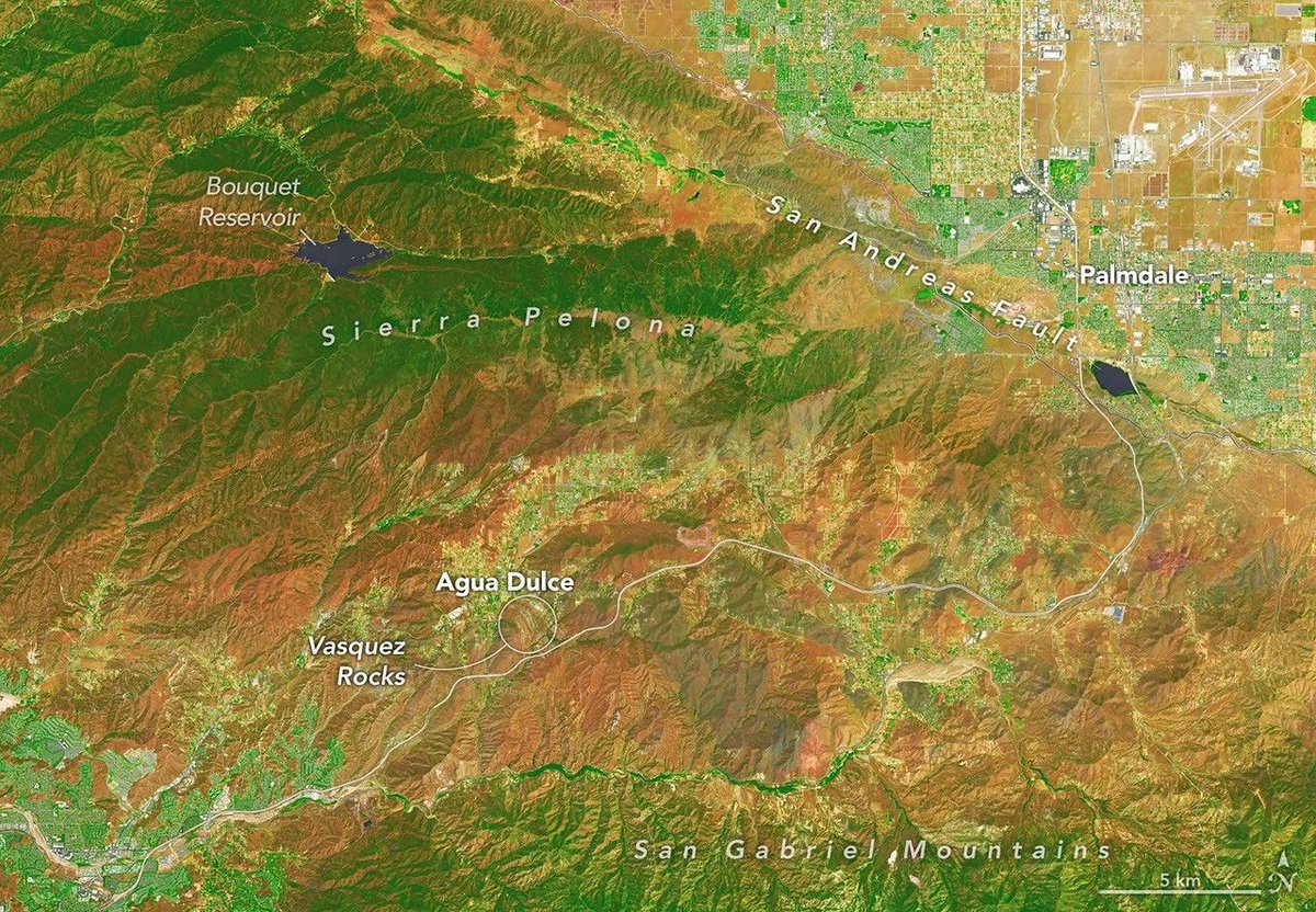
Several of the outcrops atVasquez Rocks Natural Areain Southern California jut from the arid landscape of the Soledad Basin at remarkable angles.
Geologists estimate that the tilt ofsedimentary rockstrata found in the area averages50 degrees, steep enough that many of the otherworldly formations appear to point toward the stars.
That’s fitting, in some ways, because the rocks have served as one of the Star Trekfranchise’s favorite backdrops ever since the show’s inaugural season, when Captain James T.
Kirk scrambled up the jagged terrain during aniconic battlewith a member of areptilian alien species.
Viewed from space, the Vasquez Rocks are considerably less dramatic, but they show up clearly as bands of gray nestled between mountain ranges in thesefalse-color and natural-color images captured by theOLI onLandsat 9.
The false-colorview incorporates shortwave-infrared and near-infrared observations that accentuate differences in the landscape’s vegetation in comparison to the natural-color image on the right.
The Vasquez Rocks didn’t start out pointing skyward.
When they were forming 25 million years ago, sedimentwas spread acrossalluvial fans—cone-shaped deposits that develop as fast-moving streams empty onto relatively flat plains.
The sediment likely hadn’t traveled far, much of it eroding from nearby uplands.
Over time, the alluvial fan deposits were buried and cemented into thick layers of sandstone and conglomerate rock.
Over millions of years, the region was then reshaped by the interaction oftectonic platesjust to the east.
Two plates grind past each other along a boundary that includes the San Andreas Fault, astrike-slip faultwhere the North American plate moves southeast and the Pacific plate northwest, contributing to the powerful tectonic forces that ripple throughout the region.
Eventually this tectonic activity led to the uplift and deformation of the Soledad Basin, with sedimentary layers gradually tilting, folding, and rotating.
Once they were exposed at the surface, millions more years of weathering and erosion sculpted the formations further, removing softer material and leaving the more resistant sandstone and conglomerate fins and ridges that wow visitors today.
The rock formations represent far-flung moons and planets inseveral other Star TrekepisodesandVulcan, Spock’s home planet, in two Star Trekmovies.
Other productions have highlighted the Vasquez Rocks as well.
They make appearances in dozens of othertelevision shows and movies, including the science fiction series Westworld, For All Mankind, and Battlestar Galactica.
NASA Earth Observatory images by Michala Garrison, using Landsat data from theU.S. Geological Survey. Story by Adam Voiland.
JPEG
County of Los Angeles Department of Parks and Recreation, Vasquez Rocks Natural Area. Accessed September 4, 2026.
Directors Guild of AmericaVasquez Rocks. Accessed September 4, 2026.
Hendrix, E. & Ingersoll, R.Tectonics and alluvial sedimentation of the upper Oligocene/lower Miocene Vasquez Formation, Soledad basin, southern California.GSA Bulletin, 98, 647-663.
Los Angeles TimesHow Vasquez Rocks, L.A.’s onetime outlaw hideout, became ‘Star Trek’s’ favorite alien landscape. Accessed September 4, 2026.
NASA55 Years Ago: Star Trek Debuts, Begins an Enduring Relationship with NASA. Accessed September 4, 2026.
Painter, D.Didn’t I see these rocks in the movies? Yes, of course—they are the Vasquez Rocks. Accessed September 4, 2026.
Santa Clarita Valley Historical Society, via YouTubeVasquez Rocks, California | Natural History. Accessed September 4, 2026.
ScreenRantAll 10 Star Trek Episodes Filmed At California’s Vasquez Rocks. Accessed September 4, 2026.
SCVTVLand of the Sunny Slopes: A History of Vasquez Rocks. Accessed September 4, 2026.
Space.comTrekkies honor ‘Star Trek’s’ 60th birthday with fan events, special screenings, and a world record Vulcan salute. Accessed September 4, 2026.
Stay up-to-date with the latest content from NASA as we explore the universe and discover more about our home planet.
Once below a shallow sea, Jabal al Fāyah now stands above the desert in the United Arab Emirates as a…
The drying of the massive lake exposed playas that became the setting for feats of engineering and technological ingenuity, as…
Buoyant volcanic rock fragments from an underwater eruption drifted across the Bismarck Sea and choked island coasts.
Subscribe to the Earth Observatory and get the Earth in your inbox.
NASA’s Earth Observatory brings you the Earth, every day, with in-depth stories and stunning imagery.
Explore Earth Science
Open access to NASA’s archive of Earth science data