Winter near the Antarctic Circle brings months of frozen darkness, when sea ice chokes ocean waters and many of its denizens hunker down to ride out the harsh conditions.
But as winter began to release its icy grip, an uncommonly clear satellite image revealed that part of this remote realm was still very much awake, at least volcanically speaking.
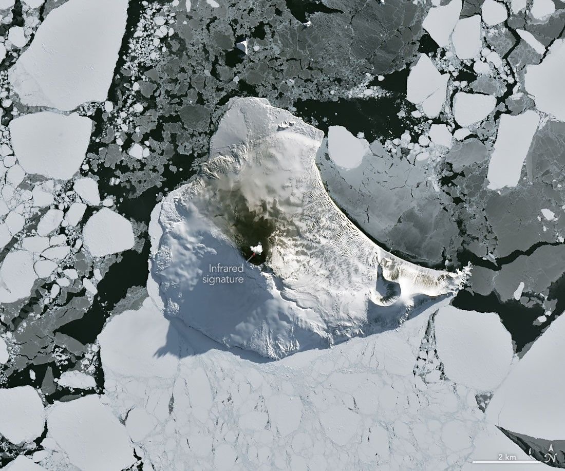
Mount Michael, the stratovolcano at the center of Saunders Island, rises above the ice-filled South Atlantic Ocean in this image, acquired with theOLI on the NASA-USGSLandsat 8satellite on August 24, 2026.
The natural-color image is overlaid with an infrared signal, shown in red, revealing heat from the persistent lava lake in its summit crater.
A puff of a volcanic plume hovering over the peak, along with darkened snow on its northern slopes, also suggests ongoing activity.
Saunders Island is one of the South Sandwich Islands, a string of small volcanic peaks about 350 kilometers long that formed from the South American platesubductingbeneath the tiny South Sandwich plate.
Regular eruptions, including at Mount Michael, have occurred on these islands in recent centuries.
Because of the volcanoes’ remoteness, scientists rely on satellite data to understand their activity.
Ananalysisof thermal anomalies in Landsat, Sentinel, andASTER observations spanning 30 years led researchers to conclude that Mount Michael hosts a persistentlava lakein its summit crater.
Only a handful of other volcanoes on Earth, includingKīlauea, Nyamulagira, and Erta Ale, are known to have similar, frequently active features.
Thermal observations from theMODIS andVIIRS instruments have also enabled long-term monitoring of Mount Michael.
Data provided throughMIROVA, a near-real-time volcanic hot spot detection system, indicate that low-intensity activity has been ongoing at the volcano for the past several years.
Other observations from NASA’sAurasatellite show that emissions of sulfur dioxide and other gasesare commonat Mount Michael.
The cloud-free window over Mount Michael would close in short order.
One week later, when Landsat 9passed over the island, a more active atmosphere had returned.
But the weather patterns interacted with the island to put on a spectacle of their own.
The 843-meter-high peak jutting from the ocean disturbed passing winds to produce a series ofwave cloudsresembling thewake of a ship, a familiar phenomenon in this region.
False-color imagerycaptured by NASA’sAquasatellite indicates that avolcanic trackcaused by degassing sulfur dioxide was likely present as well.
NASA Earth Observatory images by Michala Garrison, using Landsat data from theU.S. Geological Survey. Story by Lindsey Doermann.
JPEG
Global Volcanism ProgramSaunders. Accessed September 4, 2026.
Gray, D.M., et al.Evidence for a lava lake on Mt.
Michael volcano, Saunders Island from Landsat, Sentinel-2 and ASTER satellite imagery. Journal of Volcanology and Geothermal Research, 379, 60-71.
MIROVAMichael. Accessed September 4, 2026.
NASA Earth ObservatoryVolcanic Emissions Can Change Clouds. Accessed September 4, 2026.
NASA Earth ObservatorySandwiched Wave Clouds. Accessed September 4, 2026.
NASA Earth ObservatoryLava Lake Discovered on Mount Michael. Accessed September 4, 2026.
NASA EarthdataSensing Remote Volcanoes. Accessed September 4, 2026.
Stay up-to-date with the latest content from NASA as we explore the universe and discover more about our home planet.
The volcano on Indonesia’s Halmahera Island routinely ejects ash, volcanic gases, and volcanic bombs.
Icy, isolated Peter I Island stirred up a show in the atmosphere off the West Antarctic coast.
Beaver Island is one in a string of verdant and scenic jewels in a northern Lake Michigan archipelago.
Subscribe to the Earth Observatory and get the Earth in your inbox.
NASA’s Earth Observatory brings you the Earth, every day, with in-depth stories and stunning imagery.
Explore Earth Science
Open access to NASA’s archive of Earth science data