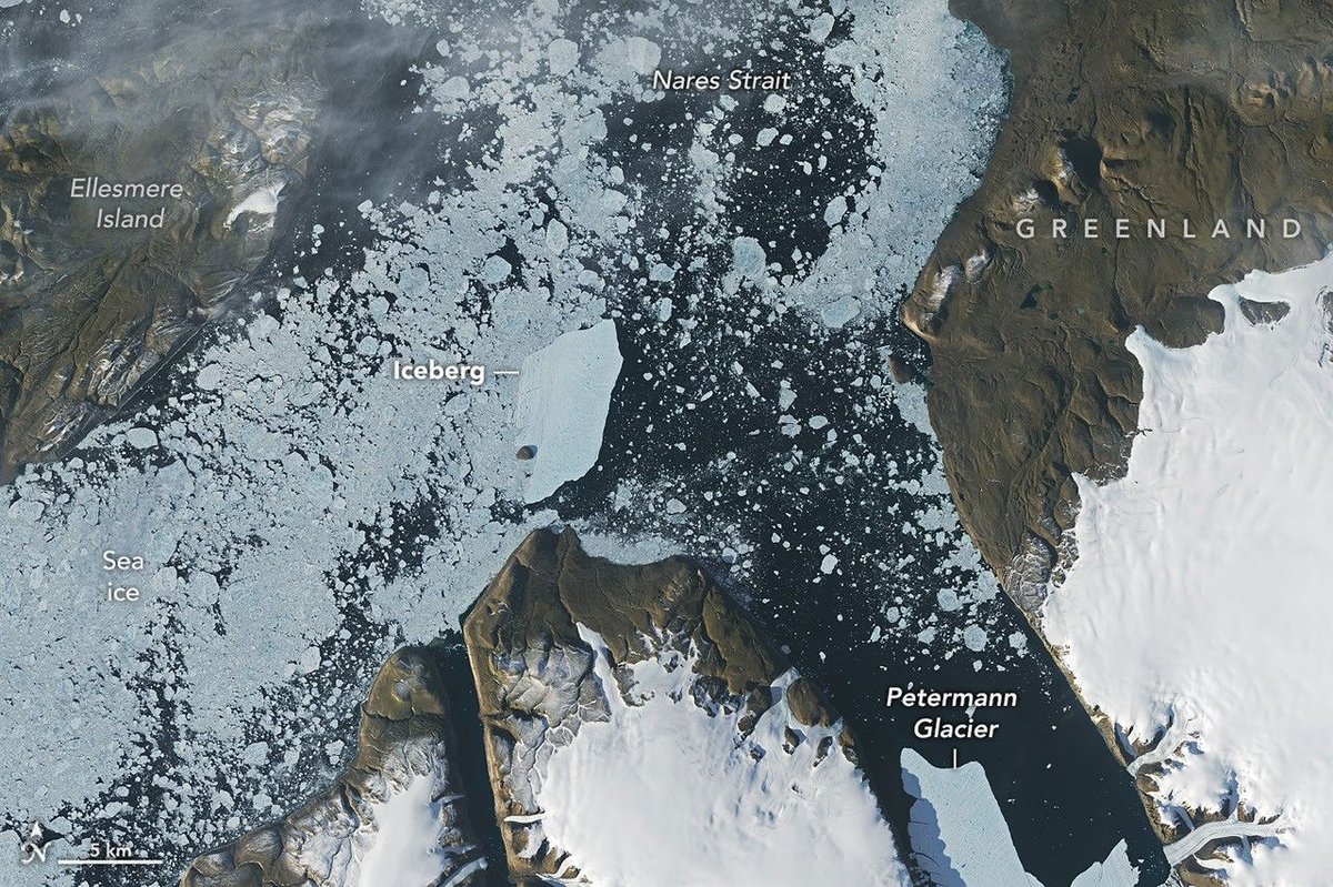
Especially notable was the berg that broke from the Petermann Glacier along Greenland’s northwest coast in August.
Roughly the size of St. Thomas in the U.S. Virgin Islands, it was the largest calving event by any Arctic glacier since 2020.
Iceberg calving is a routine part of an outlet glacier’s life cycle.
Scientists watch the process closely, however, along with numerous other observations of the ice and its environment, for longer-termsigns of instability.
Petermann is one of Greenland’s largest marine-terminating glaciers and acts as a gatekeeper for ice flowing from the ice sheet into the ocean.
Its future stability has implications forsea level rise.
The calving event of summer 2026 was spotted on August 4 by Adam Garbo, a doctoral student in glaciology at the University of Ottawa, in imagery from the European Space Agency’s Sentinel-1 mission.
Garbo and an international team of colleagues have been usingremote sensingto study and track the glacier’s ice tongue.
The team reported that the large tabular iceberg, or “ice island,” measured just over 76 square kilometers at the time it calved—the largest to break from the glacier since the ice island of2012.
The 2012 calving followed earlier major events in 2008 and2010.
The August 2026 event could have been even bigger.
Garbo and colleagues had been expecting a major calving once one of the large rifts they were monitoring finally cut all the way across Petermann’s ice tongue. “What surprised us was that the calving instead followed a different fracture, producing a smaller ice island than we had originally anticipated,” Garbo said.
As of late August, two large rifts remained and were expected to eventually produce new ice islands of roughly 94 square kilometers and 84 square kilometers, though the timing remained uncertain.
Glaciologist Mauri Pelto of Nichols College has also beentracking the iceberg, using images from NASA-USGS Landsat satellites, as it drifted down Petermann Fjord toward Nares Strait.
In the week since it calved, the berg drifted an average of 3 kilometers per day.
It continued toward the fjord’s junction with Nares Strait, where it rammed into a small rocky outcrop known as Joe Island.
The brief encounter is visible in images captured by theOLI onLandsat 9on August 23 and August 24.
A detailed view of the August 24 image is shown above.
Joe Island sits at the mouth of Petermann Fjord, making it one of the first obstacles a departing ice island meets.
Collisions with it—like the one thatsplit the 2010 ice islandin two—often mark the start of a berg’s breakup.
Petermann bergs tend to be thinner and more fragile than those calved by glaciers such as Greenland’s Jakobshavn and Helheim, and thinner still than Antarctica’s behemoths, Pelto noted.
“We were certainly watching closely as it interacted with Joe Island and were impressed that it survived the interaction without further fragmentation,” Garbo said.
The ice island was estimated to be less than 150 meters thick at the time of calving.
Wind and surface currents have swept it out of the fjord, and satellite images show itpivotingaway from Joe Island and continuing southwest through Nares Strait.
As it drifts, it will fracture into smaller pieces as tides, winds, currents, and melting continue to weaken the ice.
Thicker bergs that calve from tidewater glaciers without floating ice-shelf extensions can drag and even become grounded on the seafloor within the fjord, while ice islands, like those from Petermann, might run aground later in their drift.
Many ice islands have become “grounded” off the coasts of Coburg and Baffin islands.
Garbo and colleagues noted that ice islands and their fragments have been known to travel considerable distances, posing potential hazards to marine activities and infrastructure while also distributing freshwater through the ocean as they melt.
NASA Earth Observatory images by Lauren Dauphin, using Landsat data from theU.S. Geological Survey. Story by Kathryn Hansen.
JPEG
Åkesson, H.,et al.Petermann ice shelf may not recover after a future breakup. Nature Communications, 13.
Crawford, A. J.,et al.Journey of an Arctic Ice Island. Oceanography, 29, 254–263.
EosContext for the Recent Massive Petermann Glacier Calving Event. Accessed August 28, 2026.
The European Space AgencySentinel-1 captures major ice loss from Greenland glacier. Accessed August 28, 2026.
Fahrner, D.,et al.Petermann Glacier on the brink: Progress, challenges and insights. Science Advances, 12.
From a Glaciers PerspectivePetermann Glacier, NW Greenland Releases Massive Iceberg in August 2026. Accessed August 28, 2026.
NASA Earth ObservatoryRetreat at Petermann Glacier. Accessed August 28, 2026.
NASA Earth ObservatoryIce Island Drifts away from Petermann Glacier. Accessed August 28, 2026.
NASA Earth ObservatoryIce Island calves off Petermann Glacier. Accessed August 28, 2026.
uOttawaGreenland glacier break creates new ice island. Accessed August 28, 2026.
Stay up-to-date with the latest content from NASA as we explore the universe and discover more about our home planet.
Scientists relied on satellite data to understand how the Antarctic glacier lost so much ice so rapidly.
One narrowing icefall remains the linchpin for the Alpine glacier—and it may not be long for this world.
A large iceberg, observed in summer 2026, had drifted more than 1,000 kilometers south from the northeastern Greenland bay where…
Subscribe to the Earth Observatory and get the Earth in your inbox.
NASA’s Earth Observatory brings you the Earth, every day, with in-depth stories and stunning imagery.
Explore Earth Science
Open access to NASA’s archive of Earth science data